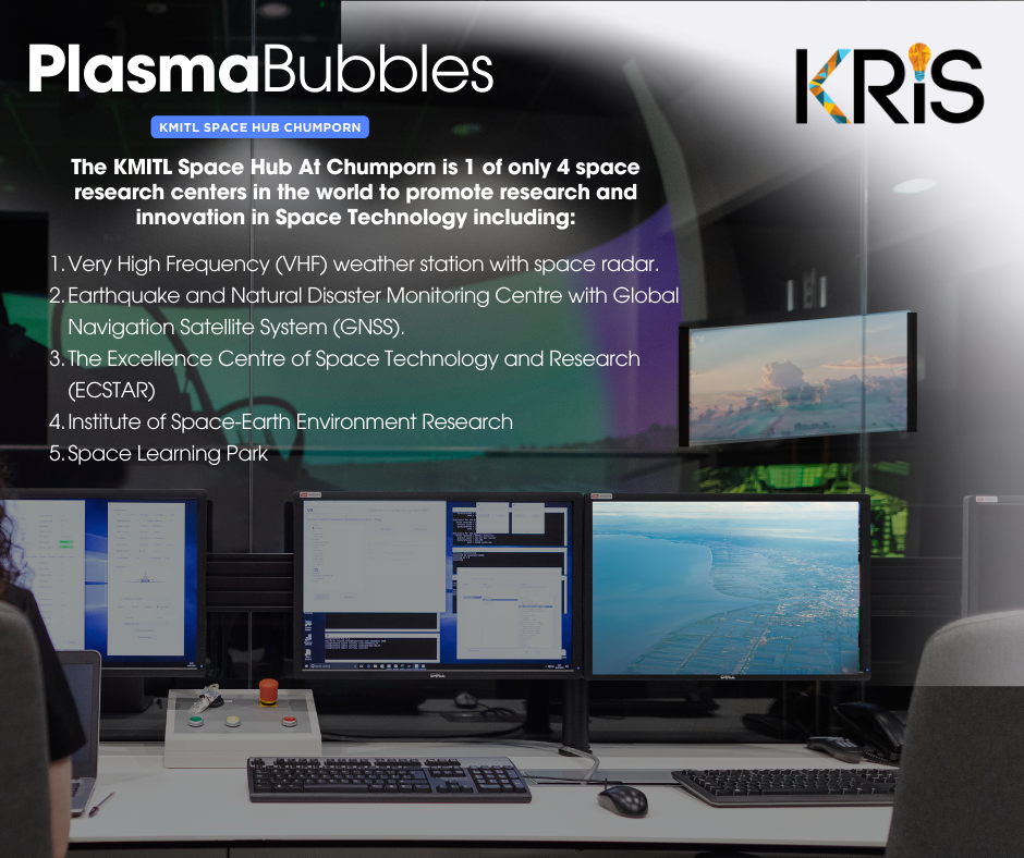
The KMITL Research and Innovation Services (KRIS) has undertaken many great projects to advance in the field of Space Economy.
Its accuracy becomes a priority for many stakeholders and related industries while safety becomes a major concern
when the precision of GPS and radio signals are off by even the slightest millimeter.
and Space Bubbles to seek out the most effective and sustainable precise satellite positioning technology solutions around.
and Ionospheric Data information to prevent disasters and safeguard for aviation in low magnetic latitude regions.
With our KMITL Space Hub set in the Chumporn Campus, we are able to capitalize on our geographical
and technical strengths to capture data on plasma bubbles that are generated nearby.
for better understanding of its disturbance and effects on satellite precision.
and researchers to put us in the right direction for future excellence, today.
KRIS ผู้บุกเบิกการค้นคว้าวิจัยเทคโนโลยีอวกาศและ Plasma Bubble ที่ KMITL Space Hub ชุมพร
สำนักบริหารงานวิจัยและนวัตกรรมพระจอมเกล้าลาดกระบัง (KRIS) ได้ดำเนินโครงการมากมายเพื่อความก้าวหน้าในด้านเศรษฐกิจอวกาศ
ในโพสต์ก่อนหน้าเราได้เล่าเรื่องราวของ ปรากฎการณ์ Plasma Bubble ซึ่งรบกวนสัญญาณดาวเทียมส่งผลต่อระบบการสื่อสาร การระบุตำแหน่งนำทาง (GPS)
ทำให้ความแม่นยำลดลง และการความพยายามในการศึกษาวิจัยเพื่อการตรวจจับและพยากรณ์ปรากฎการณ์นี้
ข้อมูลสภาพอวกาศ (space weather – SW) เป็นสิ่งจำเป็นสำหรับอุตสาหกรรมการบิน การสื่อสาร โลจิสติกส์ และการนำทาง
การระบุความแม่นยำของตำแหน่งเป็นสิ่งสำคัญสำหรับผู้มีส่วนได้ส่วนเสียในอุตสาหกรรมที่เกี่ยวข้องจำนวนมากที่ต้องพึ่งพาเทคโนโลยีนี้ไปใช้ประโยชน์
ในขณะที่ความปลอดภัยกลายเป็นข้อกังวลหลักที่สำคัญมาก เมื่อความแม่นยำของสัญญาณ GPS และสัญญาณวิทยุหายไปแม้เพียงเล็กน้อย
จะเกิดปัญหาที่ส่งผลกระทบมากมาย จึงเป็นเหตุผลที่ KRIS และ KMITL Space Hub ชุมพร
ได้ผนึกกำลังกับหน่วยงานที่มีความเชี่ยวชาญของโลกในการตรวจสอบข้อมูลสภาพอวกาศ และ ฟองอวกาศ (Space Bubbles)
เพื่อค้นหาโซลูชันเทคโนโลยีเพื่อการระบุตำแหน่งดาวเทียมที่แม่นยำและมีประสิทธิภาพที่สุด
ตั้งแต่ปี 2019 เราได้ริเริ่มโครงการทุนวิจัย ASEAN-IVO ซึ่งมุ่งเน้นการพัฒนาเครื่องมือเป็นหลักโดยใช้ข้อมูล GNSS และIonospheric
เพื่อป้องกันภัยพิบัติและความความสูญเสียที่จะเกิดกับภาคอุตสาหกรรมที่เกี่ยวข้อง
นอกจากนี้เรายังทำงานร่วมกับสถาบันวิจัยแห่งชาติประเทศญี่ปุ่น National Institute of Information and Communications Technology (NICT)
ติดตั้งระบบเรดาร์ Equatorial Plasma Bubble (EPB) สำหรับตรวจจับปรากฎการณ์ Plasma Bubble ที่เกิดขึ้นตามธรรมชาติ
โดยสถานที่ตั้ง KMITL Space Hub ที่วิทยาเขตชุมพรเป็นหนึ่งในสถานที่ที่ดีที่สุดในโลก
ในการติดตั้งเรดาห์ตรวจสภาพอวกาศ เนื่องจากมีที่ตั้งอยู่ใกล้กับเส้นศูนย์สูตรแม่เหล็กโลกเหมาะสมสำหรับการตรวจจับและพยากรณ์ปรากฎการณ์นี้ได้อย่างแม่นยำ
ความร่วมมือกับ NICT ประเทศญี่ปุ่นเพื่อสำรวจข้อมูลสภาพอวกาศนี้ ถือเป็นจุดเริ่มต้นที่สำคัญในการเชื่อมโยงงานวิจัยสู่การใช้งานและการพัฒนานวัตกรรมเทคโนโลยีด้านอาวกาศในอนาคต
โปรดติดตามตอนสุดท้ายของเรื่องราว Plasma Bubble จาก KRIS